1/4
SkyDemon screenshot 0
SkyDemon screenshot 1
SkyDemon screenshot 2
SkyDemon screenshot 3
SkyDemon Icon

SkyDemon

Divelements Limited
Trustable Ranking IconVertrauenswürdig
2K+Downloads
36.5MBGröße
Android Version Icon5.1+
Android-Version
3.16.12(14-02-2024)Letzte Version
-
(0 Bewertungen)
Age ratingPEGI-3
Installationsanleitung
1
Herunterladen und Installationsdatei öffnen
2
Unblock AptoideAptoide is a safe app! Just tap on More details and then on Install anyway.
3
Schließe die Installation ab und öffne Aptoide
app-card-icon
DetailsBewertungenVersionenInfo
1/4

Beschreibung von SkyDemon

SkyDemon is one of Europe's most popular solutions for VFR flight planning and in-flight navigation.


Use this app to access your SkyDemon subscription on your Android device, unlocking SkyDemon's powerful features while on the move.


FLIGHT PLANNING FEATURES


- SkyDemon vector charts are the clearest aeronautical charts you'll ever use, with dynamic airspace clipping and choice of map layers

- Route planning is as simple as touching consecutive waypoints and dragging to make changes

- Virtual Radar shows how your route relates to airspace, terrain, obstructions and other features

- Pilot Log facility calculates headings and groundspeeds from actual wind data, and shows useful frequencies

- Plates and other documents for relevant airfields are displayed automatically as you plan, and many are available georeferenced for use in flight

- Intuitive pan, pinch and rotate support with no loss of map clarity or text legibility

- File a VFR flightplan for your route directly to air traffic controllers

- Automatic TAF, METAR and SIGMET briefing as you plan a route, with graphical decoding

- Rainfall data can be overlaid on the main map, with animation, showing the trend of rainfall over time

- Integration of GAFOR route forecasts for Switzerland, Austria, Slovenia and Croatia

- Both narrow-route and area NOTAM briefings available, updated as you plan

- Advanced NOTAM graphical interpretation and depiction on the main map

- Easily print your PLOG and the output from various briefings

- Warnings for airspace and other potential hazards to your flight, updated in real time

- Airfield Admin Information shows useful contacts and other details for airfields featured in our charts

- Forecast winds aloft are automatically retrieved for the flight time and displayed on the map

- Create an advanced flight performance profile for each aircraft you use

- ATS Routes mode offers an alternative chart presentation for flight along airways

- Accurate fuel, weight and balance calculations including flight costings

- Create an unlimited number of user-defined waypoints

- Analyse your track logs for posterity

- Choose between six different vector chart styles

- Extensive European chart coverage as standard


GPS NAVIGATION FEATURES


- Intelligent warnings for approaching airspace, NOTAM, obstacles, terrain and other hazards

- Virtual Radar shows a side-on projection of all approaching features and how your trajectory relates to them

- Vector map automatically follows the aircraft in north up, track up or course up orientation

- Clear and concise instruments show you flight statistics and help keep you on track

- An HSI/ILS instrument helps you keep to your planned route and line up early for approach

- Live Pilot Log shows progress through your route, ETAs, ATAs and useful frequencies based on your current position

- TerrainSafe dynamically colours mountainous terrain around you to quickly identify safer areas

- Direct To allows easy re-routing in a hurry by picking from a selection of nearby airfields

- Approach Information shows runway diagrams, TAF, METAR, NOTAM and other airfield details useful for making an approach

- Live updates of TAF and METAR while in flight, with associated alerts*

- Extended runway centrelines appear automatically on the map as you near your destination airfield

- Permanent display of position relative to nearest well-known waypoint, for position reporting

- Easy changing of the planned route while in flight by touching and dragging


* Internet connection required for live weather update while in flight

SkyDemon ist einer von Europas beliebtesten Lösungen für VFR Flugplanung und Flugnavigation.


Mit dieser App Ihre SkyDemon Abonnement auf Ihrem Android-Gerät zugreifen, SkyDemon die leistungsstarken Funktionen während der Fahrt zu erschließen.


Flugplanung FEATURES


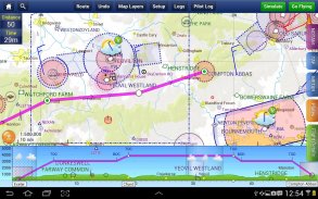
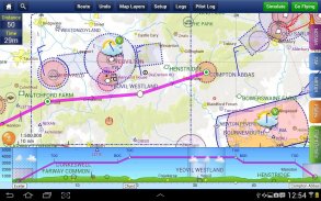
- SkyDemon Vektorkarten sind die deutlichsten Luftfahrtkarten Sie überhaupt, mit dynamischer Luftraumausschnitt und die Wahl der Karten-Layer verwenden

- Die Routenplanung ist so einfach wie aufeinander folgende Wegpunkte zu berühren und Änderungen vornehmen, ziehen an

- Virtual Radar zeigt, wie Sie Ihren Weg zum Luftraum, Gelände, Hindernisse und andere Merkmale bezieht

- Pilot Log Anlage berechnet Schriften und groundspeeds aus aktuellen Winddaten und zeigt nützliche Frequenzen

- Platten und andere Dokumente für relevante Flugplätze werden automatisch angezeigt, wenn Sie planen, und viele sind für den Einsatz im Flug georeferenzierte verfügbar

- Intuitive Pfanne, kneifen und drehen Unterstützung ohne Verlust der Karte Klarheit oder Lesbarkeit der Texte

- Direkt an Fluglotsen einen VFR Flugplan für Ihre Route Datei

- Automatische TAF, METAR und SIGMET Einweisung, wie Sie planen, eine Route, mit grafischer Dekodierung

- Niederschlagsdaten können auf der Hauptkarte überlagert werden, mit Animation, die Entwicklung der Niederschläge im Laufe der Zeit zeigen,

- Integration von GAFOR Route Prognosen für die Schweiz, Österreich, Slowenien und Kroatien

- Beide Schmal Route und Bereich NOTAM-Briefings zur Verfügung, aktualisiert, wenn Sie planen,

- Erweiterte NOTAM grafische Interpretation und Darstellung auf der Hauptkarte

- Einfaches Drucken Ihre PLOG und die Ausgabe von verschiedenen Briefings

- Warnungen vor Luftraum und andere potenzielle Gefahren zu Ihrem Flug in Echtzeit aktualisiert

- Airfield Admin Informationen zeigt nützliche Kontakte und andere Details für die Flugplätze in unsere Charts vorge

- Prognose Höhenwinde sind für die Flugzeit automatisch abgerufen und auf der Karte angezeigt

Erstellen einer erweiterten Profil Flugleistung für jedes Flugzeug Sie verwenden -

- ATS Routen-Modus bietet eine Alternative Kartendarstellung für den Flug entlang Atemwege

- Genaue Kraftstoff, Gewicht und Balance Berechnungen inklusive Flug Kalkulationen

Erstellen Sie eine unbegrenzte Anzahl von benutzerdefinierten Wegpunkte -

Analysieren Sie Ihre Track-Protokolle für die Nachwelt -

Wählen Sie zwischen sechs verschiedenen Vektor-Grafik Stile -

- Umfangreiche europäische Chart Abdeckung als Standard


GPS-Navigationsfunktionen


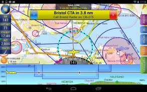
- Intelligente Warnungen für die Annäherung an Luftraum, NOTAM, Hindernisse, Gelände und andere Gefahren

- Virtual Radar zeigt eine Side-on-Projektion aller Annäherung an Funktionen und wie Sie Ihre Flugbahn betrifft sie

- Vektorkarte folgt automatisch das Flugzeug in Norden, verfolgen oder natürlich Ausrichtung

- Übersichtliche Instrumente zeigen Sie Flugstatistik und sorgt auf dem richtigen Weg

- Ein HSI / ILS Instrument hilft Ihnen, Ihre geplante Route behalten und frühzeitig für Ansatz ausrichten

- Live-Pilot Log zeigt Fortschritte durch Ihre Route, ETA, ATAs und nützliche Frequenzen basierend auf der aktuellen Position

- TerrainSafe dynamisch Farben bergigen Gelände um Sie zu identifizieren, schnell sicherere Gebiete

- Direct To ermöglicht eine einfache Re-Routing in Eile durch eine große Auswahl in der Nähe Flugplätze Kommissionierung

- Annäherung Informationen zeigt Landebahn Diagramme, TAF, METAR, NOTAM und weitere Flugplatz Details, die zur Herstellung eines Ansatzes

- Live-Updates von TAF und METAR während des Fluges, mit zugehörigen Warnungen *

- Erweiterte Landebahn Mittellinien erscheinen automatisch auf der Karte, wie Sie in der Nähe Ihres Zielflugplatz

- Permanente Anzeige der Position relativ zum nächsten bekannten Wegpunkt, für Positionsmelde

- Einfacher Wechsel von der geplanten Route während des Fluges durch Berühren und Ziehen


* Internetverbindung für die Live-Wetter-Update erforderlich während des Fluges


SkyDemon – Version 3.16.12

(14-02-2024)
Weitere Versionen
Was ist neu- Cloud storage of routes is now automatic- There is a new Warnings tab in planning mode which shows all planning warnings for your route- Flight Details settings have been moved to the Route menu

Es gibt noch keine Bewertungen oder Beurteilungen! Um die erste zu hinterlassen, installiere bitte

-
0 Reviews
5
4
3
2
1
Info Trust Icon
Garantiert gute AppDiese App hat die Sicherheitstests gegen Viren, Malware und andere Schadattacken bestanden und enthält keine Bedrohungen.

SkyDemon – APK Informationen

APK Version: 3.16.12Paket: aero.skydemon.skydemonandroid
Kompatibilität zu Android: 5.1+ (Lollipop)
Entwickler:Divelements LimitedBerechtigungen:10
Name: SkyDemonGröße: 36.5 MBDownloads: 1.5KVersion : 3.16.12Erscheinungsdatum: 2024-04-03 20:53:43Min. Bildschirmgröße: SMALLUnterstützte CPU: x86, x86-64, armeabi-v7a, arm64-v8a
Paket-ID: aero.skydemon.skydemonandroidSHA1 Signatur: B5:93:F4:AF:BB:59:24:01:D6:48:ED:41:16:45:B5:91:27:BB:60:9CEntwickler (CN): Tim DawsonOrganisation (O): SkyDemonOrt (L): SherborneLand (C): GBBundesland/Stadt (ST): Dorset

Neueste Version von SkyDemon

3.16.12Trust Icon Versions
14/2/2024
1.5K Downloads36.5 MB Größe

Weitere Versionen

3.16.11Trust Icon Versions
13/12/2023
1.5K Downloads20 MB Größe
3.16.10Trust Icon Versions
27/9/2023
1.5K Downloads20 MB Größe
3.16.9Trust Icon Versions
14/6/2023
1.5K Downloads20 MB Größe
3.16.8Trust Icon Versions
4/5/2023
1.5K Downloads20 MB Größe
3.16.7Trust Icon Versions
1/4/2023
1.5K Downloads20 MB Größe
3.16.6Trust Icon Versions
26/1/2023
1.5K Downloads27 MB Größe
3.16.4Trust Icon Versions
26/10/2022
1.5K Downloads27 MB Größe
3.16.3Trust Icon Versions
25/5/2022
1.5K Downloads27 MB Größe
3.16.2Trust Icon Versions
12/4/2022
1.5K Downloads27 MB Größe

Apps in derselben Kategorie

Das könnte dir auch gefallen...